|
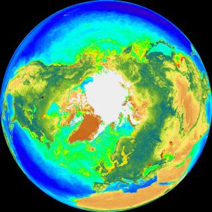
Explanation: The Sea-viewing Wide Field-of-view Sensor (SeaWiFS) instrument onboard the orbiting SeaStar spacecraft can map subtle differences in Earth's ocean color. These North (left) and South Pole projections are based on SeaWiFS measurements made between September 1997 and July 1998. The "color" strongly depends on how sunlight is reflected by free-floating phytoplankton - photosynthesizing organisms which contain chlorophyll. Chlorophyll absorbs blue and red light and reflects green. Since the tiny phytoplankton are tremendously important, forming the beginning of the food chain for sea life, SeaWiFS color maps can help track the activity of ocean planet Earth's biosphere.
|
January February March April May June July August September October November December |
| ||||||||||||||||||||||||||||||||||||||||||||||||
NASA Web Site Statements, Warnings, and Disclaimers
NASA Official: Jay Norris. Specific rights apply.
A service of: LHEA at NASA / GSFC
& Michigan Tech. U.
Based on Astronomy Picture
Of the Day
Publications with keywords: Earth - ocean - north pole - south pole
Publications with words: Earth - ocean - north pole - south pole
See also:
- APOD: 2025 October 12 Á All the Water on Europa
- APOD: 2025 December 8 Á Flying Over the Earth at Night
- APOD: 2025 September 7 Á All the Water on Planet Earth
- APOD: 2025 June 15 Á Two Worlds One Sun
- APOD: 2024 December 29 Á Methane Bubbles Frozen in Lake Baikal
- Interplanetary Earth
- Earthset from Orion
